Transportation Network Optimization for Public Transit: Enhancing Efficiency with GIS Modeling
Explore Our Portfolio: Showcasing Success Stories in GIS & Web GIS Innovation and Development.


Portfolio
Transportation Network Optimization for Public Transit: Enhancing Efficiency with GIS Modeling
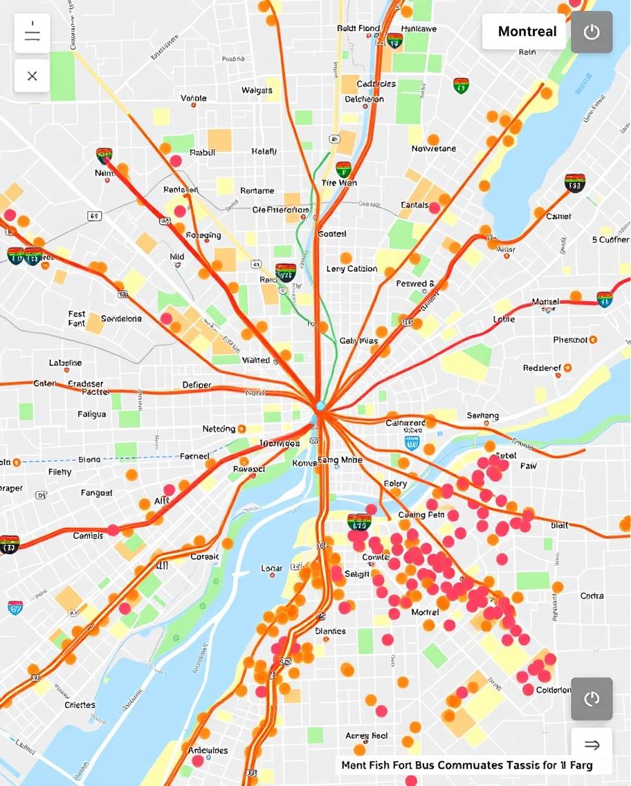
Global GeoSoft developed a GIS-based transportation network optimization tool for the Montreal Transit Authority. This tool analyzed traffic patterns, transit routes, and commuter data to optimize the city’s public transportation network. The project resulted in reduced travel times and improved service efficiency, benefiting thousands of daily commuters.
- Clients Detail
- Sevices Provide
- Project Timeline
- Location
- Montreal Transit Authority
- GIS Application Development & Spatial Analysis
- 90 days for Completions
- Ontario, Canada
Projects Detail
The Transportation Network Optimization project involved the development of a GIS platform that analyzed traffic patterns, commuter density, and route efficiency across Montreal’s public transit system. The Transportation Network Optimization platform allowed transit planners to visualize current routes, identify bottlenecks, and model potential improvements.
By incorporating real-time data and advanced spatial analysis tools, the Transportation Network Optimization platform helped the Montreal Transit Authority make data-driven decisions that improved service reliability and reduced operational costs. The Transportation Network Optimization project also included the integration of commuter feedback, enabling the authority to tailor services to the needs of the public.
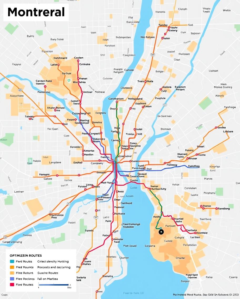
Global GeoSoft’s Transportation Network Optimization project for the Montreal Transit Authority was a comprehensive initiative aimed at improving the efficiency and reliability of the city’s public transportation system. The project involved creating a GIS-based platform that could analyze real-time traffic data, commuter density, and route efficiency to optimize bus and metro services across Montreal. By using this platform, transit planners were able to identify bottlenecks, streamline routes, and reduce overall travel times for commuters.
The Transportation Network Optimization platform was equipped with advanced modeling tools that allowed planners to simulate different routing scenarios and their impact on the city’s transportation network. This capability was particularly valuable in addressing peak-hour congestion and ensuring that public transit services met the demands of a growing population. The Transportation Network Optimization also integrated commuter feedback, which was used to refine and adjust routes in response to public needs. This made the transit system more responsive and user-friendly, ultimately improving customer satisfaction.
Additionally, the project emphasized sustainability by focusing on reducing the carbon footprint of the transit network. By optimizing routes and improving efficiency, the platform contributed to lower emissions and a greener city. The integration of GIS technology into Montreal’s transit planning process marked a significant step forward in the city’s efforts to build a more efficient and environmentally sustainable public transportation system.
The implementation of the GIS-based Transportation Network Optimization has also fostered greater collaboration among different departments within the Montreal Transit Authority. With real-time data sharing capabilities, various teams—such as operations, planning, and customer service—can access the same information, enabling them to coordinate their efforts more effectively. This cross-departmental collaboration ensures that everyone is aligned with the same goals, enhancing the overall efficiency of the public transit system. As a result, the authority can respond swiftly to issues, implement changes more seamlessly, and keep commuters informed about service updates and modifications.
Moreover, the project’s impact extends beyond immediate transit improvements. By incorporating community engagement into the optimization process, the Montreal Transit Authority has established a feedback loop with residents. Surveys, public meetings, and digital platforms allow commuters to voice their concerns and suggestions directly. This involvement not only enhances the sense of community ownership over the transit system but also ensures that the services provided align with the actual needs of the population. Through continuous feedback, the transit network remains dynamic and responsive, adapting to the evolving landscape of urban transit demands while encouraging a culture of active civic participation in transportation planning.
GIS Application Development Consultation
Global GeoSoft’s GIS Application Development Consultation for the Montreal Transit Authority focused on creating a platform that could handle the dynamic nature of public transit data. The consultation included advice on integrating real-time data feeds, optimizing route algorithms, and ensuring the platform’s scalability as the city’s transit network evolved. Global GeoSoft also provided training for transit planners and ongoing support to ensure the system’s success.
Our Other Project
- Collaborative Crime Mapping Sol.
- Geo-Collaborative Epidemic Control
- Disaster Response and Management
- GIS-Driven Urban Expansion
- GIS-Enhanced Cooperative Work
- Railways Assets Mgmt. System