Climate Change Impact Assessment for Northern Communities: GIS-Driven Environmental Analysis
Explore Our Portfolio: Showcasing Success Stories in GIS & Web GIS Innovation and Development.


Portfolio
Climate Change Impact Assessment for Northern Communities: GIS-Driven Environmental Analysis
Global GeoSoft is actively collaborating with the Northwest Territories Environmental Agency on an innovative project aimed at assessing the impacts of climate change on northern communities. This initiative utilizes advanced Geographic Information System (GIS) technology to analyze key environmental factors such as temperature changes, ice melt patterns, and wildlife migration. By integrating various datasets, the project provides a comprehensive overview of how climate change is affecting the region. This valuable information enables stakeholders to understand the intricate dynamics of the local ecosystem and the challenges faced by communities in adapting to these changes.
The insights gained from this project are crucial for supporting informed policy-making and developing effective community adaptation strategies. By providing critical data on the ongoing shifts in the environment, Global GeoSoft helps local governments and organizations design targeted interventions that address the specific needs of northern communities. This proactive approach aims to enhance resilience against climate change impacts, ensuring that residents are better equipped to cope with the evolving landscape and its associated challenges. Through this partnership, Global GeoSoft is committed to fostering sustainable development and promoting environmental stewardship in the Northwest Territories.
- Clients Detail
- Sevices Provide
- Project Timeline
- Location
- Northwest Territories Environmental Agency
- GIS Consulting Services
- 90 days for Completions
- Northwest Territories, Canada
Projects Detail
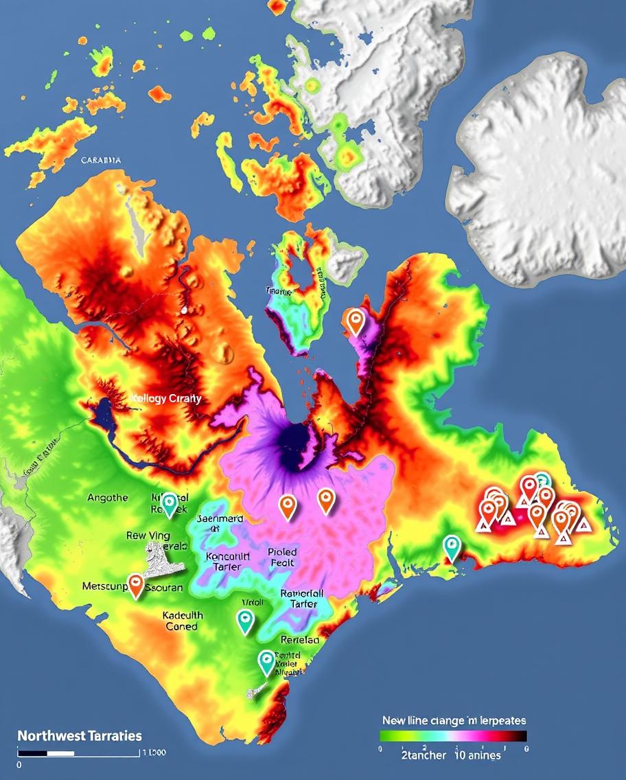
The Climate Change Impact Assessment project involved the development of a GIS platform that analyzed temperature changes, ice melt patterns, and wildlife migration routes in the Northwest Territories. The platform provided detailed maps and reports that highlighted the areas most affected by climate change, enabling the Environmental Agency to develop targeted adaptation strategies.
The project also included community engagement initiatives to raise awareness about the impacts of climate change and the importance of sustainable practices. By providing accurate and timely data, the platform supported the agency’s efforts to protect vulnerable communities and ecosystems.
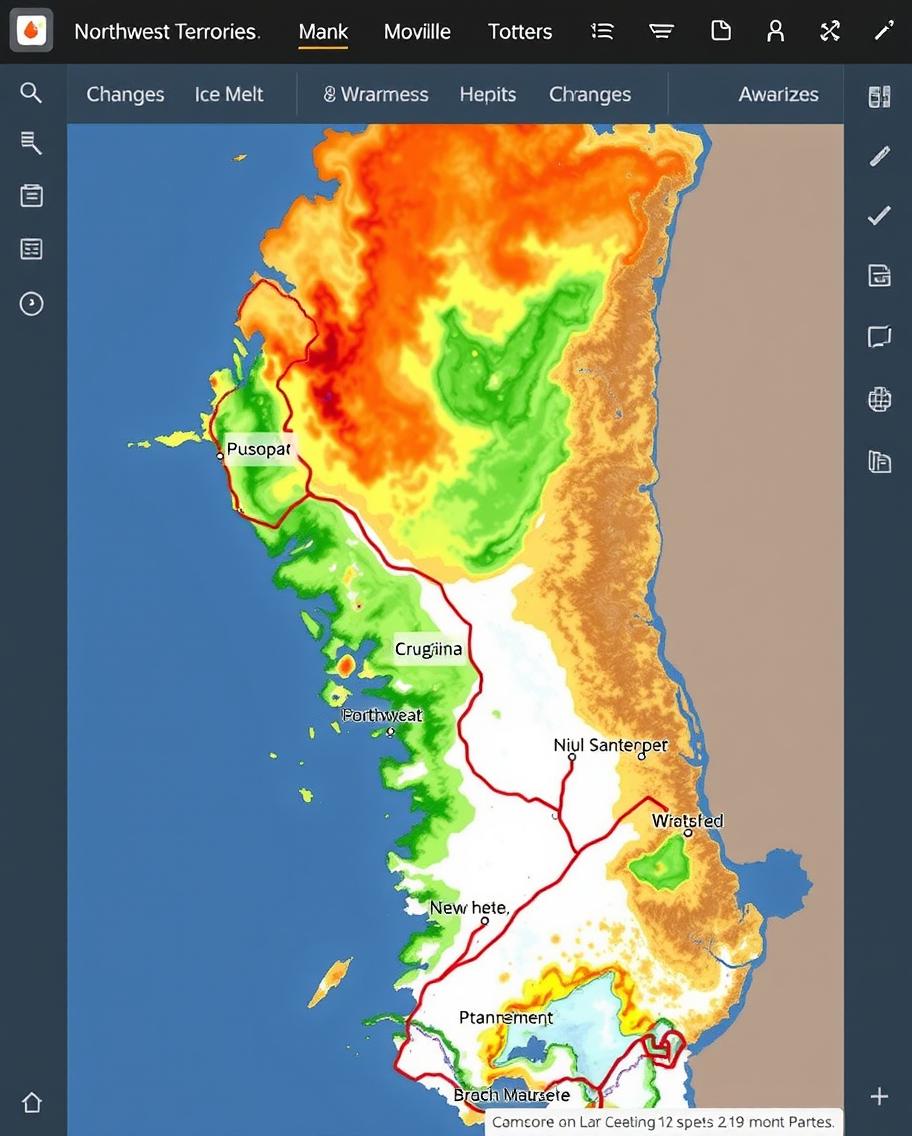
Global GeoSoft’s Climate Change Impact Assessment project for the Northwest Territories Environmental Agency was a vital initiative aimed at understanding and mitigating the effects of climate change on northern communities. The project involved developing a GIS platform that could analyze a wide range of environmental data, including temperature changes, ice melt patterns, and wildlife migration routes. This platform provided the agency with critical insights into how climate change was impacting the region, enabling them to develop targeted strategies for adaptation and mitigation.
The GIS platform was particularly valuable in visualizing the spatial and temporal dynamics of climate change in the Northwest Territories. By mapping changes in temperature and ice cover over time, the platform highlighted the regions most vulnerable to climate-related disruptions. This information was crucial for the agency as it developed policies to protect communities and ecosystems, such as identifying areas where infrastructure might be at risk or where wildlife conservation efforts were needed.
Community engagement was a key aspect of the project. Global GeoSoft worked closely with local communities and Indigenous groups to ensure that the platform incorporated traditional knowledge and addressed local concerns. This collaborative approach not only enriched the data used in the platform but also fostered greater community involvement in climate resilience efforts. The success of this project demonstrated the critical role that GIS technology plays in addressing the complex challenges of climate change, particularly in vulnerable regions like the Arctic.
GIS Application Development Consultation
Global GeoSoft’s GIS Application Development Consultation for the Northwest Territories Environmental Agency focused on building a platform that could handle the complexities of climate data. The consultation included recommendations on data collection, analysis techniques, and the integration of traditional knowledge from Indigenous communities. Global GeoSoft also advised on best practices for community engagement and the use of GIS tools to support climate resilience.
Our Other Project
- Collaborative Crime Mapping Sol.
- Geo-Collaborative Epidemic Control
- Disaster Response and Management
- GIS-Driven Urban Expansion
- GIS-Enhanced Cooperative Work
- Railways Assets Mgmt. System